We get asked A LOT of stuff about Atikokan by locals, visitors, and by people who happen to come across us by accident. Below are some of the things we get asked the most.
Q: Where did Robert and Kathrene Pinkerton live when Kathrene wrote “Wilderness Wife”?
A: Robert and Kathrene had a cabin on Steep Rock Lake here in Atikokan near Wagita Bay. The exact site where their cabin stood is now below the water level and cannot be visited but you can still visit the area by water or land.
Q: Is there somewhere for me to charge my electric vehicle?
A: YES! Thanks to a partnership between Ontario Power Generation and Hydro One Atikokan has a level 3 charging station as a part of the Ivy Charging Network. A 20-minute charge should allow your electric vehicle to travel about 100 km.
Q: What is there to do in Atikokan?
A: There are TONS of things to do in Atikokan it just depends on what your interests are and what level of movement you’re comfortable with. Locals and visitors alike spend most of their time outdoors staying active on our trails, snowmobiling, ATVing, hunting, fishing, golfing, and paddling but if the weather isn’t very nice or you’d prefer something indoors you can visit the Atikokan Museum, Pictograph Gallery, or visiting local shops and restaurants. Explore our website to see what Atikokan has to offer!
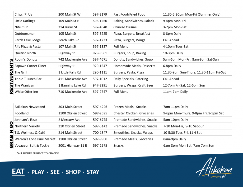
Q: Where can I go to eat in town?
A: Atikokan has lots of options depending on your needs. Check out the “Eat” section of our website or for an overview of everything you can check out the page below. This guide to Atikokan’s restaurants can also be found on the “Menu” tab of our Facebook page.
Q: How do I get to Atikokan?
A: Most people drive to visit Atikokan but you can also get here by bus with Ontario Northland Transport. Atikokan also has a municipal airport if you have a private plane or charter. Atikokan can also be accessed by paddling or hiking the Trans-Canada Trail!
Q: Can I visit the mines? Is there anything to see?
A: The old mine sites are still available to visit and can be easily accessed by road but there are a number of areas that are no longer accessible due to safety concerns. Most of the landmarks are gone or are now underground or water but there are still partial buildings, roads of iron ore pellets, and pieces of equipment to find. At the very least there are some beautiful views.
Check out our page on visiting the mines to learn more.
Q: I want some maps and brochures, is there somewhere I can get them?
A: There are brochures and maps at a number of businesses around town but the best selection can be found at the Atikokan Travel Information Centre (Open Summers) or the Atikokan Economic Development Corporation (Open Year-Round). When the information centre is closed the Atikokan Economic Development Corporation is the home of the tourism office.
If you aren’t sure the best place to go or where to get the information you can always DM Tourism Atikokan on Facebook or Instagram for help or send us an email at tourismatikokan@atikokaninfo.com.
Q: What time zone is Atikokan in?
A: It depends! Atikokan is technically located in the Central Time Zone (CST) but we don’t observe Daylight Savings Time so during the winter months our clocks align with Eastern Standard Time (EST). Atikokan chose not to observe the time change years ago because of the mine operations and hasn’t seen the need to change it since.
Q: How big is Atikokan?
A: That depends on what you mean by big. The 2021 census had our population at 2,642. If you meant the size of our borders Atikokan goes North to the start of Marmion Lake, East to about halfway through Plateau Lake, South to the bottom of Jim Lake, and West to halfway through Jackfish Lake.
If you want to see it on a map check out this map from the Government of Ontario. Once you accept their terms zoom closer to the Atikokan area and on the menu under “Administrative Boundaries” check the box for “Lower or Single Tier Municipality” and the town borders will show up.
(If you’re ever bored this is a good way to learn the names of every lake in the province!)
Q: What does Atikokan mean? How do I say it?
A: The name Atikokan is believed to be derived from Ojibwa-Chippewa meaning “caribou bones” or “caribou crossing”, the town was once a wintering ground for herds of caribou. Atikokan is pronounced phonetically as At-a-ko-can.
Atikokan is on the doorstep of one of Ontario’s most traditional wilderness areas, as Quetico Provincial Park stands among the best for its beauty and its ruggedness. We’re only too happy to have you here, whether it’s for a day, for a week, or a lifetime. We are the Canoeing Capital of Canada. We are the Gateway to Quetico Provincial Park. We are Naturally Wild.